DRAFTING OF A GEOSITE PROJECT IN THREE EVOLUTIONARY STAGES
The geological importance of the middle But Valley geosite lies in its well-defined sequence of evolutionary stages (Fig. 3), in chronological order:
- a massive rockslide from Mts. di Rivo and Cucco, which caused a large main scarp and gave origin to a thick chaotic deposit in the valley bottom (about 10,000 years ago).
- a palaeolake more than 6 km2-wide and about 100 m-deep, which formed due to blocking of the upstream water-flow of the River But; for almost 5,000 years, several tens of meters of muds, sands and gravels piled up on the palaeolake bottom.
- the palaeolake emptying followed the collapse of the rockslide mass, about 5,000 years ago; this produced a terraced erosive surface in the lacustrine-deltaic sediments. At the same time, greater erosion of the main scarp of the rockslide and along the valley slopes resulted in the progradation of wide alluvial fans. In recent times, these alluvial fans have been cut off by fluvial erosion.
The same sequence (1-2-3) could be divided into many more events or ‘evolutionary stages’.
These are, in order: a) massive rockslide; b) upstream water-flow stopping; c) lake formation; d) sedimentation onto the lake bottom; e) erosional collapse of the rockslide mass; f) emptying of the palaeolake; g) terraced erosion surfaces in the lacustrine deposits; h) erosion of the valley slopes; i) alluvial fans progradation; and j) recent fluvial cut-off of the alluvial fan deposits.
Download pdf file – Scarica il file pdf
However, such a division is not advisable, as dealing with more than three evolutionary stages for one geosite would make it more difficult to understand and memorize. Therefore, two -or three at most- main evolutionary stages are sufficient to briefly describe the history of a composite geosite in order to make this evolution easily understandable.
On the other hand, those visiting the geosite should be informed of the main field evidences the interpretation is based on.
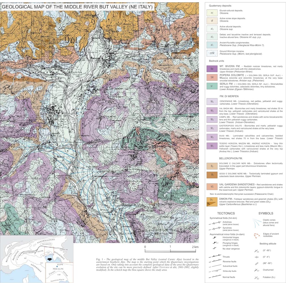
In the middle But Valley geosite, geomorphological and sedimentary processes occurred over an area of about 40 km2 and over 10,000 years, from the early Holocene to the Present. It is of fundamental importance to look for field tracks and choose the best and most spectacular and outstanding of these in order to adequately document the discrete evolutionary stages of the area. The many features forming a composite geosite, such as those considered, can be highlighted in many and different ways.
The first of these methods are photographs with captions providing explanations. Nevertheless, photographs are often not sufficient to provide the layman with an understanding of the true meaning of the depicted object, and in many cases it will be necessary to include signs and graphic markers in the pictures.
Another suitable way to represent field data are drawings. In some cases drawings pointing out meaningful outlines accompany photographs. At other times, drawings may represent cross-sections, which are useful in order to show a particular morphology and/or stratigraphic units and the tectonic features in depth. Drawings can also be used to show the stratigraphic column of the site, i.e. the vertical distribution of the sediments and their mutual relations in the investigated area (stratigraphic framework).
One of the most interesting types of drawing is the block-diagram. This is a 3D picture generally used to show wide areas of smoothed morphology and/or peculiar features. With regard to 3D images, the DTM (Digital Terrain Model) -also known as DEM (Digital Elevation Map)- should in particular be mentioned, as the most advanced technology used for representing surface morphology.
The Digital Terrain Models presented in this work were created using the TN3D desktop software produced by Terranova S.r.l. 3D modelling is based on elevation data (spatial and attribute data) obtained from vectorial CTR information at the scales 1:5,000 and 1:25,000, kindly supplied by the Cartographic Office of the Regione Autonoma Friuli-Venezia Giulia.
Potresti leggere anche:
: un’evoluzione guidata da tettonica, glacialismo e sismicità") Conoide dei Rivoli Bianchi di Tolmezzo e paleo-Lago di… Questo contributo prende in esame i caratteri geologici e soprattutto geomorfologici del settore alpino ubicato a NE di Tolmezzo (UD), comprendente i Monti Strabut, Amariana e Palavierte p.p., nelle Alpi Carniche centrali. L’indagine inizia trattando la stratigrafia del substrato e…
Conoide dei Rivoli Bianchi di Tolmezzo e paleo-Lago di… Questo contributo prende in esame i caratteri geologici e soprattutto geomorfologici del settore alpino ubicato a NE di Tolmezzo (UD), comprendente i Monti Strabut, Amariana e Palavierte p.p., nelle Alpi Carniche centrali. L’indagine inizia trattando la stratigrafia del substrato e…") XXIV GEODAY – M. di Rivo (Campanili del Lander; Arta… Sotto l’egida dell’Ordine dei Geologi del FVG Partecipazione libera con mezzi propri. Itinerario con difficoltà media. Visualizza Mappa Punto di ritrovo: Chiesetta di San Nicolò degli Alzeri
XXIV GEODAY – M. di Rivo (Campanili del Lander; Arta… Sotto l’egida dell’Ordine dei Geologi del FVG Partecipazione libera con mezzi propri. Itinerario con difficoltà media. Visualizza Mappa Punto di ritrovo: Chiesetta di San Nicolò degli Alzeri Corrado Venturini 2023 – La Macchina del tempo… Questa è la storia di quattro ragazzi troppo curiosi (Peter, Vittoria, Giulia e Matteo), compagni di classe di una Scuola media di Tolmezzo, cittadina del Nord-Est d’Italia. La loro è una vicenda personale che si interseca con la lunga Storia…
 Geo-escursione “Alta Valle del But” Venerdì 23 agosto 2024 [10.15-18] - CAI-Sezione di Ravascletto (UD). Itinerario di massima: Paluzza-Cleulis-Timau-Laghetti di Timau (vedi Locandina). Escursione gratuita, trasferimenti con mezzi propri. A seguire la geo-chiacchierata "Pericolosamente Timau!" (18.30-19.30), v. Locandina specifica.
- CON GORTANI ALLA SCOPERTA GEOLOGICA DELL’ALTA CARNIA: I… Scopo del contributo è documentare, attraverso la puntuale trascrizione, il rinvenimento di due Taccuini di appunti (con relative carte geologiche) che registrano i risultati dei rilevamenti effettuati da Michele Gortani nelle Alpi Carniche durante le campagne di ricerca svolte negli…